Plan your visit to the Painted Hills & John Day Fossil Beds
The John Day Fossil Beds National Monument is one of the most unique areas to visit in Oregon, and a bit of advance planning will help you get the most out of your stay. If you would like to see photos of the area, check out our What To See page, or continue reading below to see some of our tips and information for visiting the area. To book your stay, visit Airbnb or VRBO
Where To Stay
|
Choosing where to stay is the is the first step in planning your trip to The Pained Hills & John Day Fossil Beds. Because each of the units is spread out, finding lodging in a central location will allow you to maximize your time spent exploring the area.
Mitchell, Oregon is the most central city to see all of the units of the John Day Fossil Beds, and is only a short, 20 minute drive to The Painted Hills, making it the perfect home base. Mitchell is a very small town (population about 135), but has a great sense of community and a lot of local character, along with a small brewery, several restaurants, a market and gas station, along with several shops and a rock museum - perfect to help you enjoy your visit! Approximate drive times to Mitchell are:
|
|
Tips for Your Trip
The area is very beautiful, but quite remote. You will be amazed by the landscapes, quiet and the feeling of getting away from it all. We do recommend you plan in advance for the following:
- Expect to have little to no cell phone service. Printed maps work great, as well as knowing the general direction of where you are going in advance. Maps are available (and free) at the Thomas Condon Paleontology Center.
- Gas stations are all about an hour apart (and can be expensive). It is best to not let your tank get too empty. Gas is available in Mitchell, Spray, Fossil, Dayville & John Day.
- Food & Water: Outside of the towns listed above, which all have markets and restaurants, there is nowhere to buy food of water when out exploring. Plan to bring enough water and a lunch with you on your day trips.
- Driving: The distance between the attractions can be 45 minutes to 1.5 hours so you may want to download music, podcasts or movies ahead of time to keep everyone entertained as streaming and radio is not readily available. All of the main attractions can be accessed from paved roads (though the Painted Hills road turns to gravel inside the park), and you may encounter deer and livestock crossing the roads.
- Weather: During the summer months the temperatures can get up to 100 with little cloud cover or shade. We highly recommend bringing hats and sunscreen and a pack to carry water on hikes.
- Pets: Dogs are allowed in the John Day Fossil Beds, but must be kept on a leash at all times. If visiting Blue Basin, the Island in Time Trail has 13 short grated walkways that may be uncomfortable for paws. They are not allowed in the Thomas Condon Paleontology Center so someone will need to stay outside with them.
- Camera: If you have one bring it – you will want to capture the beautiful area!
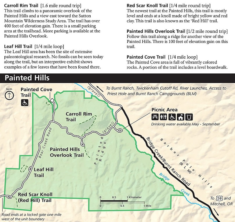
The Painted HillsOne of the 7 wonders of Oregon, the Painted Hills are comprised of 5 different areas to explore: Overlook, Painted Cove Trail, Leaf Hill, Red Scar Knoll (Red Hill) and Carroll Rim, each with their own parking area. They are often best viewed in the afternoon to evening, and the colors are particularly vibrant after it rains.
Most areas are easily walked and provide different views with stunning colors and perspectives. For a more panoramic view, hike up Carroll Rim Trail. If you have time, a visit in the morning is great too, especially for photographers, as the colors and highlights will change significantly from the evening. The road inside the park is dirt/gravel but is well maintained and suitable for most cars. RV's should not proceed past the Overlook parking area. The bathroom is a left turn before the ranger’s house – you may want to stop before heading in as those are the only ones available in the park. |
|
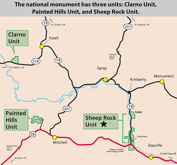
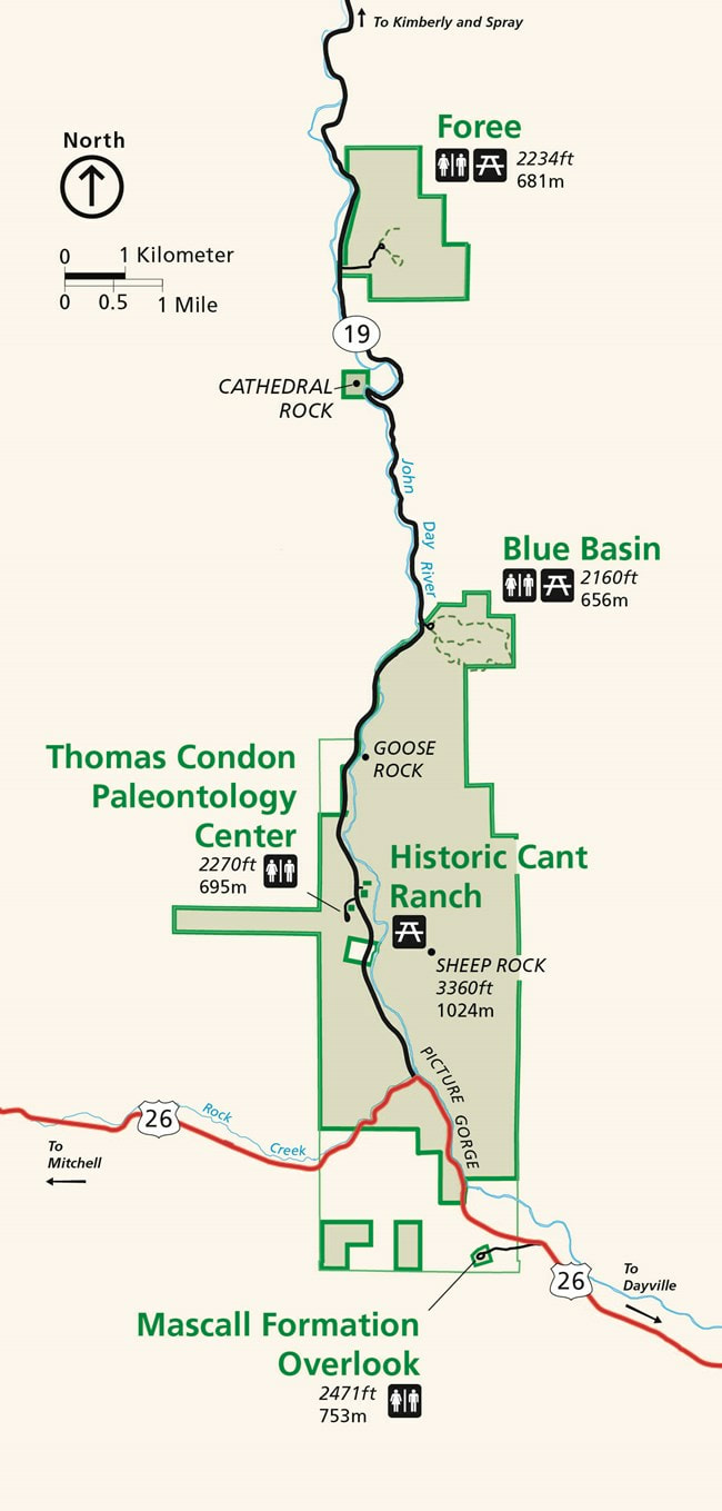
Sheep Rock Unit
|
The Sheep Rock Unit is about a 45 minute drive from Mitchell with beautiful scenery and rock formations. On the way, look for the Shoe Tree on the North side of the highway between mile marker 88 and 89. Sheep Rock is comprised of multiple attractions, each with different stops and hikes. Most are fairly easy to navigate, though they often have uneven terrain.
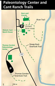
Exploring Sheep Rock can take all day depending on length of each stop. We recommend starting at the Thomas Condon Paleontology Center if you would like to speak with a ranger or get more information and brochures, explore the exhibits in the museum, and learn about the history of the area or call 541.987.2333 for seasonal hours. If you have children, you may want to participate in the Junior Ranger Program. You can explore the Historic Cant Ranch or hike overlook for views of Goose Rock. |
|
Exploring Sheep Rock
After a stop at the Paleontology Center, the next stop could be Foree (The furthest point) and working back with a stop at Cathedral Rock for photos (You will also see it driving N on 19 with another view). Foree has two sides, both very different looking and short, easy walks up. There are also Restrooms and a picnic table. If you are interested in picking fresh, seasonal fruit, you may want to stop at Thomas Orchards located in Kimberly, which is about 15 minutes past Foree. You can check their facebook page for what’s in season and directions or call for open hours (541) 934-2870.
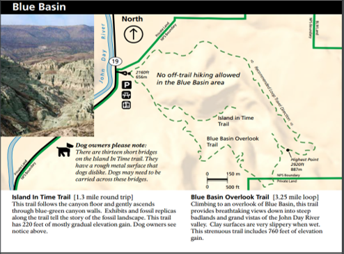
The last stop would be exploring Blue Basin. At Blue Basin, the Island in Time trail is a must do. It is fairly easy with gradual uphill and you can stop on benches, read about some of the fossils found and look at their replicas and see the dramatic views at the end. If you are bringing a dog, please note there are 13 short, grated walkways that may be uncomfortable for paws.
Overlook Trail offers stunning, panoramic views of the area and Blue Basin, but at 3.25 miles with elevation gains and very narrow winding trails, it can be difficult for many. It is also possible to start up each side of Overlook and do an up and back to explore part of the trails if it is too strenuous to do the whole thing. Entering Overlook where directed on the signs lets you get fairly close to some of the unique formations, while entering from the Island in Time Trail gives you the start of the view over the inside of Blue Basin (it is very lightly marked a little way in and veers up to the right so must look for it).
There are restrooms and a picnic area near the parking lot.
After a stop at the Paleontology Center, the next stop could be Foree (The furthest point) and working back with a stop at Cathedral Rock for photos (You will also see it driving N on 19 with another view). Foree has two sides, both very different looking and short, easy walks up. There are also Restrooms and a picnic table. If you are interested in picking fresh, seasonal fruit, you may want to stop at Thomas Orchards located in Kimberly, which is about 15 minutes past Foree. You can check their facebook page for what’s in season and directions or call for open hours (541) 934-2870.
The last stop would be exploring Blue Basin. At Blue Basin, the Island in Time trail is a must do. It is fairly easy with gradual uphill and you can stop on benches, read about some of the fossils found and look at their replicas and see the dramatic views at the end. If you are bringing a dog, please note there are 13 short, grated walkways that may be uncomfortable for paws.
Overlook Trail offers stunning, panoramic views of the area and Blue Basin, but at 3.25 miles with elevation gains and very narrow winding trails, it can be difficult for many. It is also possible to start up each side of Overlook and do an up and back to explore part of the trails if it is too strenuous to do the whole thing. Entering Overlook where directed on the signs lets you get fairly close to some of the unique formations, while entering from the Island in Time Trail gives you the start of the view over the inside of Blue Basin (it is very lightly marked a little way in and veers up to the right so must look for it).
There are restrooms and a picnic area near the parking lot.
|
|

|
Clarno Unit & Fossil
|
Clarno Unit
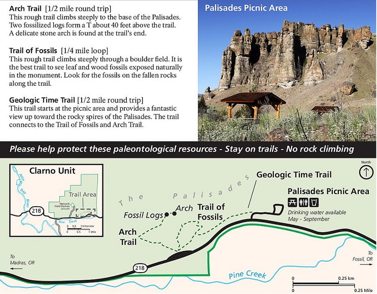
When visiting Clarno, if you want to do the Arch Trail to the top, it actually is closest to park in front of the monument (This parking area is N of the main parking lot) and start from there which saves a bit of time if not doing the Trail of Fossils. While there is elevation and the trails can be narrow and uneven, it is shorter than it looks to the top, but should not be started by anyone with mobility challenges. The restrooms and picnic area are next to the larger parking lot on the side of the monument. Digging for Fossils in Fossil: This can be done when visiting Clarno, or just as part of the drive down to the area. For more information, you can visit the Oregon Paleo Lands Center which has up to date information on any exhibits and open hours. While they do have some tools available, if you have extra gloves or a digging tool you may want to bring one. You can call for additional details (541) 763-4480. |
|
Other Areas to Explore
Shaniko: An old, almost ghost town is well worth a stop if you are driving from the north and stopping at Clarno (it’s on the way) or just can be added to the Clarno day trip if you take one. There are old buildings, a small museum, a bank and historical cars to look at. In summer there is a small market, ice cream shop and gas.
John Day River: If you continue past the Painted Hills on Burnt Ranch Road, you will head to turn offs to the John Day River and several swimming holes, boat launches and beaches. Several available are Priest Hole and BLM Hole. The roads are gravel, rocky and sometimes muddy, so a 4 wheel drive with a spare tire may be best. There are many other spots to easily access the river along the scenic byway drive where you can stop and swim, float or fish at as well, including at Service Creek.
Other Swimming Locations:
Kam Wah Chung State Heritage Site Museum
If you drive to the town of John Day there is the Kam Wah Chung Museum which is very small, but tells the fascinating story of some of the early Chinese settlers, and is very well preserved with the original items and look of the house that was left. It is free and requires a tour, which typically starts on the hour and last about an hour, but double check the schedule as it varies seasonally. There are also gas/groceries available in town.
John Day River: If you continue past the Painted Hills on Burnt Ranch Road, you will head to turn offs to the John Day River and several swimming holes, boat launches and beaches. Several available are Priest Hole and BLM Hole. The roads are gravel, rocky and sometimes muddy, so a 4 wheel drive with a spare tire may be best. There are many other spots to easily access the river along the scenic byway drive where you can stop and swim, float or fish at as well, including at Service Creek.
Other Swimming Locations:
- Ochoco Reservoir: While much of the water access is on private land, Ochoco Lake Park (about 45 Minutes from Mitchell) has day use amenities, a boat launch and a beach for public use.
- Prineville Reservoir: About 1.15 hours from Mitchell, this is a large area with several sites for swimming, fishing, hiking and exploring. https://oregonstateparks.org and put Prineville Reservoir in the search bar (the correct link will be a few down in the results)
Kam Wah Chung State Heritage Site Museum
If you drive to the town of John Day there is the Kam Wah Chung Museum which is very small, but tells the fascinating story of some of the early Chinese settlers, and is very well preserved with the original items and look of the house that was left. It is free and requires a tour, which typically starts on the hour and last about an hour, but double check the schedule as it varies seasonally. There are also gas/groceries available in town.